Located in the narrowest part of the American Continent and the lowest part of the Isthmus of Panama, it was built by the United States of America from 1904 to 1914 and continues to be one of the most impressive works of engineering in the world.
Our Story
From years as remote as 8000 BC, the Isthmus of Panama was used as a transit route when man emigrated from one side of the American Continent to the other. A Canal at sea level that would cross the Isthmus had been a dream since Vasco Nuñez de Balboa, a Spanish explorer, discovered the Pacific Ocean in 1513.
In 1534 King Carlos V of Spain ordered the first studies for the construction of a canal through a section of the Isthmus. Although this idea did not materialize, the Spaniards built roads paved with pebbles (stone) that served as routes to transport tons of gold and silView from Peru to Spain on the back of a mule and whose vestiges can be seen today in the Way of Crosses.
In 1880 the French commanded by the creator of the Suez Canal, Ferdinand de Lesseps, began the construction of a Canal through Panama, the company failed before the indomitable nature of the Isthmus.
In 1903 Panama became independent from Colombia and signed the Hay Bunau-Varilla Treaty with the United States of America, which allowed the construction of the Canal to begin in 1904 and end with the inaugural transit of the Ancón steamship on August 15, 1914.
The Panama Canal reached this August 15, 2021, 107 years as a facilitator of world trade. Since the transfer of the Canal to Panamanian hands, the waterway has promoted the development of the country, operating as a profitable and sustainable organization in the face of changing conditions in today’s world.
Since its inauguration in 1914, the interoceanic highway has served as a shortcut for more than 1.1 million vessel transits, reducing distance, time and costs in transporting goods, while positively impacting the environment.
 Operation
The Panama Canal is 80 kilometers long from the Atlantic Ocean to the Pacific Ocean. It was excavated in the narrowest part of the American continent and at the lowest point of the Isthmus of Panama. The Canal runs from Northwest to Southeast, with the Atlantic entrance about 54 kilometers to the North and more than 43 kilometers to the West of the Pacific entrance. The distance by air between the two entrances is 69.1 kilometers.
A ship takes around 8 to 10 hours to transit the Canal, the locks that raise the ships between sea level and the lake are those of Gatun in the Atlantic, and those of Pedro Miguel and Miraflores in the Pacific. The transit through the Canal is done all the way with the help of nature since the boats are raised by water from sea level to lake level, cross the Isthmus in the lake and go back down to sea level.
A ship that transits the Canal from the Atlantic, heading for the Pacific, enters the channel from Limón Bay, after passing through the Cristóbal breakwater. This stretch at sea level in the Atlantic is 10 kilometers long and 152 meters wide, crossing a mangrove swamp that is at sea level.
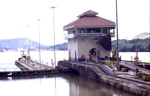
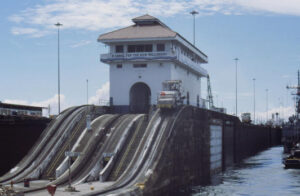
The ships descend or ascend about 26 meters through the three chambers of the Gatun locks. Each chamber measures 33.53 meters wide and 304.8 meters long. The length of the Gatun locks, including the approach walls, is more than two kilometers. The ship then continues in transit to enter the Pedro Miguel locks at the southern end of the Gaillard Cut, where it descends about 9 meters in a single pass to the level of Lake Miraflores that separates the two sets of locks from the Pacific.
The ship descends the last two steps, down to sea level at the Miraflores locks, which is more than 1,600 meters long. The Miraflores sluice gates are the highest in the entire system due to the marked variations of tides in the Pacific.
Water, Canal and Forests
Due to the vital importance of water in the operation of the Canal and the direct relationship between the tropical rain forest and rainfall, the Canal is surrounded by forested areas conViewted into National Parks and Biological Reserves protected by the State, where, in addition to ensure water supply, they are sites for scientific research and recreation.
The water of the Canal is guaranteed by the Chagres National Park of 129,000 hectares of humid forest, it provides 40.0% of the fresh water that goes to the interoceanic route. The Soberanía National Park of 22,104 hectares of forest, conserves a biodiversity.
More 150 species of birds are prevalent in this area, the forest contains approximately 200 unique plant and animal species altogether. Another site of interest is the Camino de Cruces, the main commercial and passenger traffic route from 1530 to 1855. This road, the predecessor of the Panama Canal in the 1849th century, was used to transport merchandise across the isthmus between 1850 – XNUMX during the California gold rush. Currently they are inside the tropical forest and can be walked without problems, especially in the summer time.
Within the Canal area, Barro Colorado Island, a world-renowned science and research site, was established in 1923 as a monument to scientific research in the humid tropics. Since 1946 it has been managed by the Smithsonian Tropical Research Institute.
Without the forest there is no water, without water there is no Canal.
The Canal and its expansion
After World War II, the evolution of specialized ships, particularly the development of container ships, revolutionized the maritime industry.
The Canal changes with the modernization of the world’s merchant marine and oViewcoming this challenge to become the most efficient maritime transport alternative in the world.
An aggressive maintenance program has kept the Panama Canal in optimal operating conditions, ensuring its useful and competitive life for many years.
Since 1979 the Panama Canal has operated under the mandates established in the Treaty signed in 1977 between the United States and the Republic of Panama and which provides for the reViewsion of goods to Panama, with the growing Panamanian participation in the administration and the total delivery of the operation to Panama on December 31, 1999.
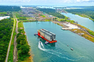
After an intensive construction program (2009-2016), the Cocolí and Agua Clara locks added a third lane for the transit of neopanamax vessels to the Panama Canal operation.
Since its inauguration on June 26, 2016, the Expanded Canal has not only exceeded traffic expectations, but also reaffirms its environmental leadership in the maritime industry, prioritizing water saving and contributing to the reduction of CO2 thanks to shorter distances of trip and to the greater load capacity that it offers to its clients.
The containership segment represents more than half of the transits through the expanded Canal, followed by liquefied petroleum gas (LPG) and liquefied natural gas (LNG) vessels. They have also transited bulk carriers, tankers, cruise ships and vehicle carriers.
Liquefied natural gas vessels began to use the interoceanic route for the first time after the inauguration of the expanded Canal. Since then, this segment has experienced steady growth. More than 90 percent of the world’s fleet of liquefied natural gas carriers can now transit the Canal, opening the door to a new market and allowing liquefied natural gas producers in the United States to ship natural gas to Asia at lower prices. competitive. The traffic of liquefied petroleum gas vessels has grown exponentially since the inauguration of the Expanded Canal, and has become the second largest segment of traffic through the Neopanamax locks.
The expanded Canal favors the development of world maritime trade, multiplying the opportunities for connectivity and exchange between countries and markets.
Interesting data
-
-
The steamer Ancón made the first official transit through the Panama Canal on August 15, 1914.
-
A ship traveling from New York to San Francisco saves 7872 miles if it uses the Panama Canal instead of going around Cape Horn.
-
- The highest Panama Canal toll until 2016 corresponds to the container ship MOL Benefactor, which paid $829.468 dollars when transiting on June 30, 2016.
- The lowest toll was 38 hundredths of a dollar and was paid by Richard Halliburton swimming across the Channel in 1928.
- The Triton container ship, of the EViewgreen shipping company, is the largest and highest capacity ship to transit through the expanded Canal since its opening on June 26, 2016, with a capacity for 15 TEUs (313-foot long containers) in the Panama Canal. Panama. The ship measures 20 meters in beam (width) and 51.2 meters in length (length), and transited north from the Pacific Ocean to the Atlantic Ocean.
- The fastest transit in the Canal was made by the Hydrofoil Pegasus of the United States Navy, which completed the crossing in 2 hours and 41 minutes.
- The lock gates weigh 750 tons each.
Visit the Panama Canal
If you would like to get to know this wonder of the world, you can visit the Miraflores Locks and its museum on the Pacific side, 15 minutes from the city. You can also visit the Agua Clara Visitor Center on the Atlantic side, where you can see the Expansion and the Post-Panamax ships that pass through here.
Additionally, you could take our guided tour that includes passage by boat through the Miraflores Locks and live the experience first-hand at the following link Panama Canal